But one of the more reliable data sets in this timeframe is the Rutgers University Global Snow Lab.
http://climate.rutgers.edu/snowcover/
The data goes back to 1966, which isn't bad for the variable. At any rate, the December 2009 data came out today. And while November was warm, the globe had built a decent snow base in October. So when December turned cold, the snowpack exploded, reaching some interesting levels.
For the Northern Hemisphere as a whole, this December had the 2nd greatest extent of snow of any December since 1966....which includes some action packed winters in the 60s and 70s. The only year ahead of it was 1985, one of the coldest winters in recent memory.
For North America, Greenland and the USA, December ranked #1 among all Decembers.
Among El Nino years, 2009 absolutely blew any other year out of the water in North America and the Northern Hemisphere. Here are the charts just for El Nino years. I don't have the graphs for all years on me, but you can plot them yourself if you want from site above. Click to enlarge them.
Northern Hemisphere:

North America:

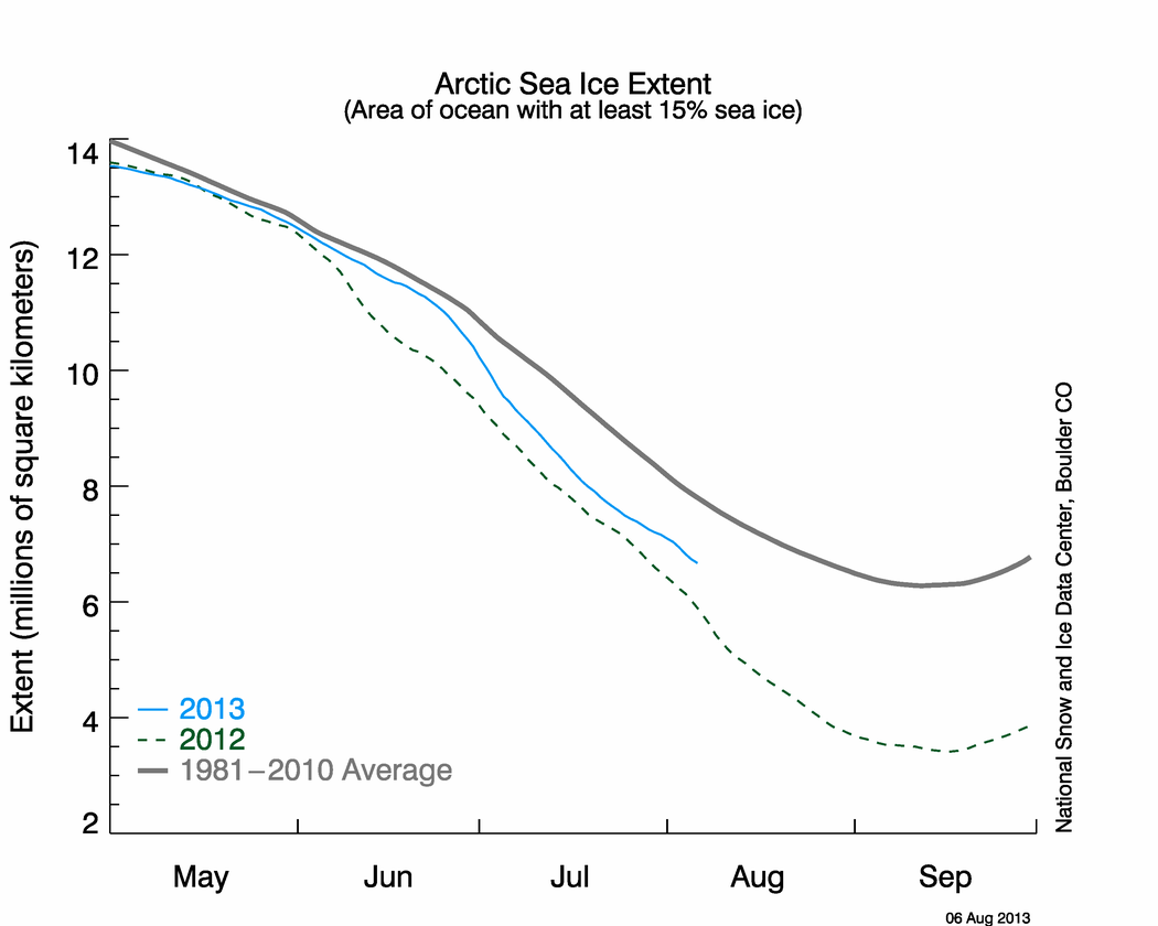
What does this mean? Well, one could argue absolutely nothing. It's one year...what difference does it make? But if you look at the 2000s as a whole, this year is well ahead of pace of any other year. Same with the 90s. And 2008-09 wasn't terribly different... The bottom line is that we've been building up snow cover, Arctic sea ice extent and colder weather:
 Sea ice is running ahead of or along the 2007-08 line, which I believe was when things "bottomed out." What's more interesting about this is that this is all occurring when the Arctic Oscillation (a measure of air pressure or blocking across the Arctic) is running at levels not seen in years. What does that mean? It means the Arctic has been much warmer than normal....which typically needs to happen to get the sort of cold we're experiencing nationally and almost globally right now.
What's even more remarkable about all this. We're doing it in the face of a borderline strong El Nino. The general theory is that El Nino generally warms the planet. That's just how it works. But this year, that warming is being masked by other things at work, namely the blocking and the situation in the Northern Pacific Ocean. The fact that we're blowing through all this despite the fact that we have a decent El Nino is incredible.
Weather is not climate. Obviously for climate change discussions, one winter does not a climate make. But the fact is that we've been dealing with some colder years now, we're equaling or exceeding certain values in some of these variables we use to measure how the globe is working that has not been seen since the 1950s and 1960s. The theory of global warming suggested that all these things were unreachable again in the warming world. Heck, 10 years ago, the British were saying that snow would be incredibly rare 10 years from then. Obviously that was wrong. If anything, I think this should force people to pause, step back and ask themselves what's going on here.
